 Sometimes building software is like building a castle in a swamp.
You build the software, it burns down, falls over and sinks in the swamp. So you have to rebuild.
When I put a previous blog post on Reddit, a number of Redditors commented that the mountain symbols would benefit from a greater range of sizes. With all the mountains about the same size, they tend to make a uniform jumble when grouped together:


The problem is that smaller mountains aren't just scaled-down versions of bigger mountains. To look good, the smaller mountains need to change their character. Here's an example from the nice Ehren map from Kacey at the Cartographer's Guild:


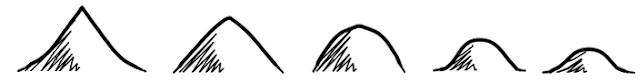
What I'd really like is the ability to smoothly interpolate between mountains that are tall, peaky and concave all the way through short, flat and convex mountains, like these hand-generated examples:

I find that re-writing code is often less effort than you might expect. The second time around, you can avoid many of the mistakes and dead-ends, and there's often a lot of code that can be partially re-used. I'm hoping that's the case this time :-).
Just wanted to say I love this blog. Keep it up man!
ReplyDeleteThanks, I always appreciate the encouragement!
ReplyDelete