 Previously I looked at scaling the mountain symbols to look good on a map; now I'm going to look at how to color the mountains to fit into the map.
Initially, I wasn't filling in the mountains at all -- just drawing the outline and shading -- but that has a problem:


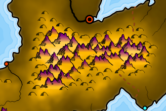
Although SVG's fill options are limited, it does offer linear and radial gradients. Radial gradients aren't of much use here, but with a linear gradient I can make the color of the mountain vary smoothly from top to bottom. I can make "snow topped" mountains by making the mountain fade to white at the top.


SVG handles gradients in a slightly unusual way. Rather than specifying the gradient for the object being filled, you create the gradient in a special definitions section of the SVG file and then reference the gradient. When I'm creating the gradients for the mountains, each one might be different, depending upon the shade at the base of the mountain. I could just create a separate gradient for each mountain, but on a map with a lot of mountains that might balloon the size of the SVG file. So instead I keep track of gradients as I create them, and if I can re-use a gradient I do so rather than create another copy of the same gradient.
Gradients could also be used to indicate something like biomes, e.g., green at low altitudes, brown in the middle altitudes, and then white at the top. I don't want to implement a three color gradient at the moment, but this is something of the effect:

You could use the color code from the underlying object. SVG doesn allow pixel level color detection for security reasons (think of script reading the entire screen and sending it back to a 3rd party). Many of the limitations of SVG are driven by the browser community rather than anything else. Still it managed to enter the HTML5 specs so for the next x years it will be safe to use.
ReplyDelete