 In previous posts I've described how Dragons Abound creates mountains. I'm now going to look at putting those mountains onto a map.
So far I've been generating mountains at a fairly large scale -- around 150 pixels square -- and located at the origin of my coordinate system. There are a couple of advantages to that. For one thing, at that scale I can see the lines clearly and it's easier to detect and fix problems. A less obvious advantage is that when I'm doing things like combining mountains, having everything in the same coordinate system and the bottom of the mountain on the X axis makes the calculations easier to understand. But to place the mountains on the map I need to scale them to the map dimensions and put them where they are needed.
(Apologies in Advance: Blogger seems to do some re-coding of uploaded images. Normally this is inconsequential, but unfortunately the small scale images in this posting seem to lose some of their sharpness. Or at least they do as I'm composing -- they may be fine when actually posted.)
As it happens, I'm generating Scalable Vector Graphics (SVG) and SVG has such transforms built-in. To scale a mountain to 1/4 size and place it at (115, 237) I just need to add an attribute
transform(translate(115 237) scale(0.25))
to the mountain. Here are some examples of mountains scaled to 1/4 size (which is about what fits into my current maps):

It might be instructive to look at how some of the human-drawn examples fair when reduced to a similar size:

These show some of the same problems -- the outline has disappeared and the shaded areas have become solid blocks of gray. On the other hand, the faces seem to retain a bit more interest thanks to the face scribbles. That seems to be true for my generated mountains as well:


The shading in the examples above isn't terrible, but I'd like make the individual lines of the shading more distinct. To do that, I increase the spacing between the shading lines and make them thicker. Here's the side-by-side:

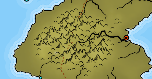
These values also have to be balanced against how the other terrain features are drawn. Right now that's only hills, which are simple semi-circles. Here's what this looks like on the map:

There are a couple of other concerns with the way I'm using these mountains on the map, as shown in this example:

The second problem is that I fill these mountains with color so that they cover up whatever lies underneath them. This ensures that the mountains properly overlap if I draw them from north to south, and the back mountains don't "show through" the front mountains. But SVG's fill capabilities are pretty limited. Right now about all I can do is fill the mountain with whatever color is under the center of the mountain. But if the background color varies, or has texture, etc., that won't look very good -- as the mountain in the upper-right shows. As long as the background color doesn't vary too radically and the mountains aren't too large, this usually works out okay, but I'd still like to be able to do a better job with this, so I'll revisit this in a later posting.
I've been following your posts for a long time and they are amazing.
ReplyDeleteDuring your post on combining mountains I noticed that the valley section looked kinda funny but you were planning on tweaking more so I didn't say anything. In this post the side of the valley are very clearly straight as seen in this picture: http://imgur.com/a/PQjtA
I added a few pixels of skew using paint.net and I think it looks better. Would you be able to subdivide the boundaries of the scribble like you did with the shadow edge?
It's only really visible in the thumbnail I highlighted since the others are too small to see.
Thanks for the inspiring work.
Ben, thanks for the thoughtful comment. I completely agree that the valley looks better with some skew. I thought the code was doing that, but it seems not, so I'll have a look. Good catch!
ReplyDelete